

BETHLEHEM, Pa. — The Lehigh Valley is under a flood watch in effect from late Friday through Sunday morning, with excessive rainfall on the way.
The watch covers a large swath of the region, including parts of northern New Jersey through east central Pennsylvania, including Berks, Lehigh and Northampton counties.
The National Weather Service warns a widespread heavy rainfall of 2 to 3 inches is forecast, with locally higher amounts possible.
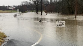
Excessive runoff could result in flooding of rivers, creeks, streams and other low-lying and flood-prone locations.
“Creeks and streams may rise out of their banks," the watch states. "Flooding may occur in poor drainage and urban areas. Low-water crossings may be flooded.”
It’s already been a wet March
Most of the Northeast was wetter than normal during the first half of March, according to the Northeast Regional Climate Center.
Precipitation ranged from near normal to more than 200% of normal across the region’s 35 major climate sites.
From March 1-15, the Allentown area picked up 2.93 inches of rain, well above the 1.73 inches considered “normal” for the time frame, measuring 169% of normal and good enough for the 13th wettest start to March ever.
EPAWA meteorologist Bobby Martrich said the incoming storm will “move just east of the spine of the Appalachians,” putting the Lehigh Valley in the bullseye for some of the heaviest rain.
EPAWA's 3/22 and week ahead outlook, covering:
— Bobby Martrich | EPAWA (@epawawx) March 22, 2024
■ Not as chilly today with milder temps, less wind
■ Impacts/timing of coastal system and heavy rain
■ A look ahead to next week and MLB opening dayhttps://t.co/rhTptSQRRz
“Rain will be especially heavy on Saturday,” Martrich said in his latest video update.
“During the day Saturday you’re going to have this low-pressure system track right over top of the region."
Timing, impacts hold in latest updates
Rain will begin overspreading the area from south to north Friday night, especially after midnight, the weather service said in its latest forecast discussion.
The heaviest rain will come Saturday afternoon when frontogenic forcing will be most prevalent, the discussion said.
Frontogenic forcing forces a vertical motion response in the atmosphere, which can result in bands of enhanced precipitation, according to the weather service.
The exact track of the low will dictate where the heaviest rainfall occurs, with precipitation “coming to an abrupt end as we head into the late afternoon and early evening Saturday,” Matrich said.
Breezy to windy conditions also are expected to develop late Saturday into Saturday night as the storm pulls away from the area.
Northerly winds are forecast to peak at 20 to 25 mph, with peak gusts of 35 to 45 mph possible.
“Given the very saturated soils with the preceding heavy rainfall, these winds may lead to some downed trees and power outages,” the weather service said.
