BETHLEHEM, Pa. — A severe thunderstorm watch is in effect for the Lehigh Valley and much of eastern Pennsylvania until 10 p.m. Wednesday.
The National Weather Service posted the watch amid a steamy afternoon as a Bermuda high remains in control of our weather pattern, bringing dangerously hot and humid air to the Lehigh Valley.
The Storm Prediction Center has also flagged an increasing threat for damaging straight line winds.
High temperatures climbed well into the 90s Wednesday, and will be around 100 degrees along the Interstate 95 corridor on what could be our hottest day of the year.
Excessive heat warnings remain in effect until 8 p.m. Wednesday for heat index values up to 106 degrees.
Millions affected
A Bermuda high is a semi-permanent area of high pressure located over the Atlantic Ocean. It’s commonly called a “heat pump” and can impact the frequency, intensity and direction of any tropical storms that develop during the summer.
This week, it aided in creating what the Weather Prediction Center calls “a major to extreme heat risk for the East Coast,” prompting excessive heat watches and warnings that extend from the Southern Plains to the Lower Mississippi Valley, Ohio and Tennessee Valleys and Central Gulf Coast.
A second area of excessive heat watches and warnings extends through the Mid-Atlantic to parts of New England.

“Extremely dangerous and potentially deadly heat, particularly for urban areas in the Southeast and East Coast, are forecast," the WPC said.
"Many daily record highs are possible for the East Coast, and numerous warm overnight lows will provide little relief.”
Severe weather risk Tuesday, Wednesday
Storms spawning multiple tornadoes blew through Iowa, Illinois and Indiana on Monday, snapping trees and utility poles, the Associated Press reported.
The storms cut power to more than 460,000 customers and businesses, including in the Chicago area, which saw multiple tornado warnings and extensive damage, the National Weather Service reported.
Tornado sirens sounding in downtown Chicago for the second night in a row. #chiwx #ilwx pic.twitter.com/szC2QS0UpK
— Dan Robinson (@stormhighwaycom) July 16, 2024
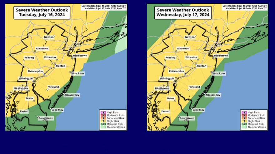
The Storm Prediction Center has most of our region in a slight risk (2 out of 5) for severe weather Tuesday afternoon and evening.
The latest guidance shows thunderstorms moving into the area late in the afternoon, the SPC said, with damaging wind gusts, heavy rain and lightning expected.
Showers and thunderstorms should taper off by midnight, but Wednesday is expected to be another day of eventful weather with highs again in the low-to-mid 90s and heat index values of 100 to 110 expected across the region.
A welcome break from the heat is finally expected to arrive Thursday.


