

BETHLEHEM, Pa. — Sustained spring warmth has been hard to come by for the Lehigh Valley, with rising temperatures cut down by robust storms.
That will be the case again this week, where temperatures in the upper 70s Tuesday were cut down Wednesday by cloud cover and light rain showers.
The rain will become much more robust in the coming days, meteorologists say.
The Lehigh Valley is under a slight risk of excessive rainfall, with the Weather Prediction Center warning of localized and isolated areas of flash flooding Thursday into Friday.
It comes a week after the region bore the brunt of a super soaker-type system, picking up a month’s worth of rain in just three days.
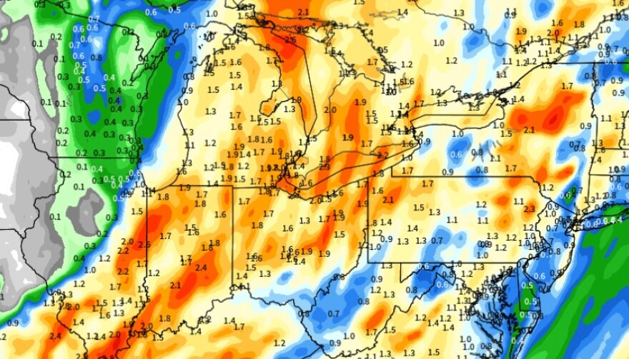
The setup
After a fairly large temperature contrast across the region Wednesday and rain throughout the day Thursday, a strong cold front is expected to push through the region overnight Thursday into Friday.
The National Weather Service expects widespread rainfall with embedded thunderstorms, it said in its latest forecast discussion.
Despite the progressive nature of the system, a hazardous weather outlook says several instances of flooding are possible on Thursday, especially in urban and poor-drainage areas and near particularly vulnerable small creeks and streams.
A waterlogged Lehigh Valley
With 3.60 inches of rain as of Wednesday morning, the Allentown area is having its third-wettest April on record, 2.5 inches above normal.
According to data from the Southeast Regional Climate Center, it’s also the second-wettest year-to-date so far, with 17.39 inches of precipitation — 6.61 inches above normal.
The Lehigh Valley is not the only location with a precipitation surplus. The year has been among the wettest on record for many major climate sites in the Mid-Atlantic and Northeast.
Other numbers include:
- Atlantic City — 12.19 inches, 6.73 inches above normal
- Bridgeport, Connecticut — 12.05 inches, 6.89 inches above normal
- Philadelphia — 10.57 inches, 5.66 inches above normal
- Wilmington, Delaware — 10.91 inches, 5.79 inches above normal
Guidance also indicates another system could move through early next week, forecasters say.
