
BETHLEHEM, Pa. — The Lehigh Valley’s first winter storm threat of the season is looming, but forecasters say it’s far too early to determine the outcome.
The weekend threat — already dubbed a “major winter storm” by the likes of AccuWeather — would be the area’s first significant snowfall in years. But the storm signal that’s emerged is just that, experts say.
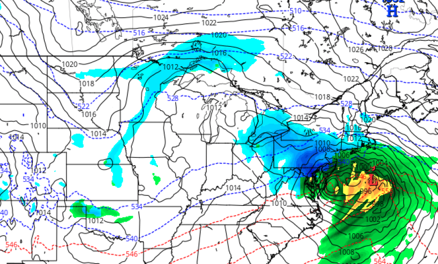
“There is a storm that will be in the Northern Gulf or the Southern Lower Mississippi Valley area, and it does move up the coast,” EPAWA meteorologist Bobby Martrich said in his latest video forecast.
EPAWA's 1/2 and week ahead outlook, covering:
— Bobby Martrich | EPAWA (@epawawx) January 2, 2024
■ Seasonably chilly for much of the week ahead
■ Early analysis of the weekend winter storm threat
■ Timing and possible impacts of heavy snow/rainhttps://t.co/Nk6x73kafP
That’s where the current forecast ends — with deterministic guidance and ensembles showing a storm moving somewhere in the Saturday night/Sunday timeframe.
Everything else remains up in the air.
Temperature
A general lack of cold air will cast doubt on the outcome of any storm, especially after the Lehigh Valley finished December with an average monthly temperature of 39.3 degrees, or 4.3 degrees above normal.
Jan. 1 kicked off the month 4.5 degrees above normal, and trends show daytime highs in the 40s through much of the week.
Early Tuesday, models depicted a storm ejecting out of the Gulf Coast and toward the mid-Atlantic region. The first question is whether it will have enough cold air to tap into once it arrives.
Track and timing
Both Martrich and the National Weather Service sounded a word of caution about what each model run currently shows.
“It is bound to change over successive runs this far out,” the weather service said in its latest forecast discussion.
PLENTY of uncertainty remains with our coastal storm this weekend - that much we know for sure. Otherwise, it is still too early for specifics at this time, but impactful snow, heavy rain, strong winds, and coastal flooding are all on the table. pic.twitter.com/cTNfuZRySI
— NWS Mount Holly (@NWS_MountHolly) January 2, 2024
Meanwhile, Martrich warned of a sharp cutoff in precipitation for a storm that could track relatively close to the coast, increasing the odds for a warmer solution for parts of the region.
“The water there is a little bit warm yet, you get an onshore fetch from that water and places like South Jersey, Delaware, even the Philadelphia metro, I really wouldn’t expect a whole lot,” Martrich said.
“I’m not saying you can’t get anything in Philadelphia, you can. But I think this is going to be a more north and west type system.”
For now, we’ll wait to see not only the track, but if the storm will pull in enough warm air that it means an abbreviated period of snow or a wintry mix for much of the region.
Current timing would bring the storm in later Saturday, with the heaviest snow falling in the overnight period and into Sunday morning.
Totals
The Allentown area (colloquially, the Lehigh Valley) measured 5.3 inches of snow all of last season.
“We can get that easily in this storm alone” if things work out, Martrich said.
But it’s too early to talk about impactful snowfall accumulations and totals, as it remains uncertain where the low will track.
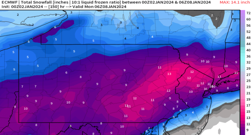
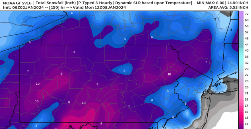
Model outputs have ranged from a heavy snow event (the European model), to the storm leaving the region with much more modest snowfall totals (the GFS/American model).
“We will simply need to wait until we get closer to the weekend before getting any more specific,” the weather service said.
Martrich echoed that sentiment, noting "we have a long way to go" in determining impacts from the storm.
