
BETHLEHEM, Pa. — Ask a local resident for a subjective rating of the week’s weather, on a scale of 1 to 10, and it might fall into negative territory this week.
We’re looking at not only a cold, damp and dreary start, we’re looking at the possibility of rain in the forecast through Thursday.
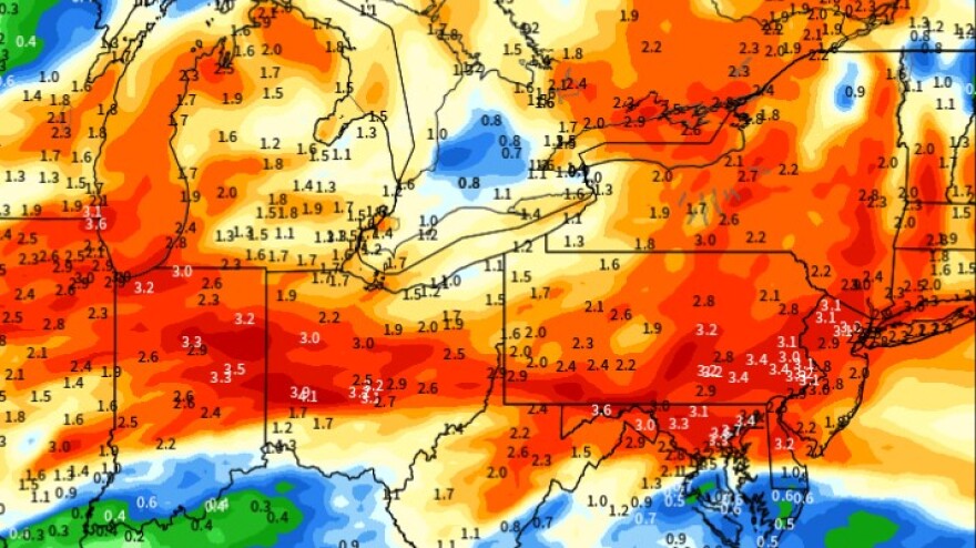
More than 3 inches of rain could fall in the Lehigh Valley over the next several days, forecasters say, with daytime highs stuck in the 40s.
What’s more, there’s potential for some wintry precipitation across the Pocono region Wednesday into Thursday.
Breaking it down
A slug of rain will move through the area early Monday, EPAWA meteorologist Bobby Martrich said in his latest video forecast.
“I think it’s primarily just a morning deal, but it might bleed into early afternoon in parts of central and southern New Jersey,” Martrich said.
EPAWA's 4/1 and week ahead outlook, covering:
— Bobby Martrich | EPAWA (@epawawx) April 1, 2024
■ Timing end of the rain today, and arrival tonight
■ Rain details for Tuesday, Wednesday, Thursday
■ Initial (National) outlook for next week's eclipsehttps://t.co/xI7tSjfW7z
Then there will be a long break between systems before another round comes in overnight and early Tuesday.
“Tuesday is going to be a wash from start to finish, and you’re going to have rain continuing overnight again into much of Wednesday,” Martrich said.
Will snowflakes fly?
As that long-duration system pulls away, Martrich said there could even be a change to snow for some far northern areas of the region.
That shot for wintry precipitation would come Wednesday night into Thursday with the development of a secondary low-pressure system.
“The development of the secondary low will be key regarding the potential for wintry precipitation across the Pocono region Wednesday,” the National Weather Service said in its latest forecast discussion.
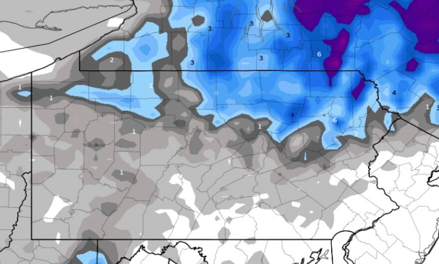
Higher elevations and far northwest New Jersey are the only spots where snow might occur, with sleet and freezing rain possible before the turnover.
“This evolution is of low confidence, however elevation looks to be key regarding accumulating snow,” the weather service said.
Martrich said snow and rain showers could continue through the day Thursday before the system finally pulls away.
While we’ll start to dry out Friday, it will remain cool, breezy and mostly cloudy.
Drier conditions and moderating temperatures are expected for the weekend, with temperatures finally pushing into the upper 50s by Sunday.
