

BETHLEHEM, Pa. - Election Day is shaping up to be a classic fall day across the Lehigh Valley and the rest of the region.
It's what will come later in the week that's likely top-of-mind for weather watchers.
Tuesday will be about 20 degrees colder than Monday, according to the National Weather Service in Mount Holly, N.J.
- Election Day looks clear and cool
- Temperatures Tuesday will be about 20 degrees colder than Monday
- We're watching what happens with Nicole, which is expected to become a hurricane and hit Florida before riding up the coast
We could see winds at 5 to 15 mph, but other than a few stray clouds, skies should remain mostly clear as you head out to the polls.
High temperatures are expected to reach the lower 50s in the Lehigh Valley, and the upper 50s today for Maryland, Delaware, New Jersey and the Philadelphia area.
What will become of Nicole?
You may have heard about potential hurricane Nicole, which is expected to impact portions of the coast of southeast and east-central Florida beginning late Wednesday or Wednesday night.
What happens after is what we need to keep an eye on.
According to the National Hurricane Center, we'll see a northwest trend in the track of Nicole and interaction between that storm and another system.
While the interaction with the two systems is now expected to occur while Nicole is southwest of our region, it's possible we could see heavy rain, winds and thunderstorms in the Lehigh Valley.
Breaking down the details
The weather service says impacts to this area would come Friday and Saturday, with a few possible hazards for our region. They are:
Rain/heavy rain: For now, the main period of rain looks to be Friday afternoon into early Saturday morning.
At this point, forecasters say there's still a broad range of solutions, with questions on where the heaviest rain will fall.
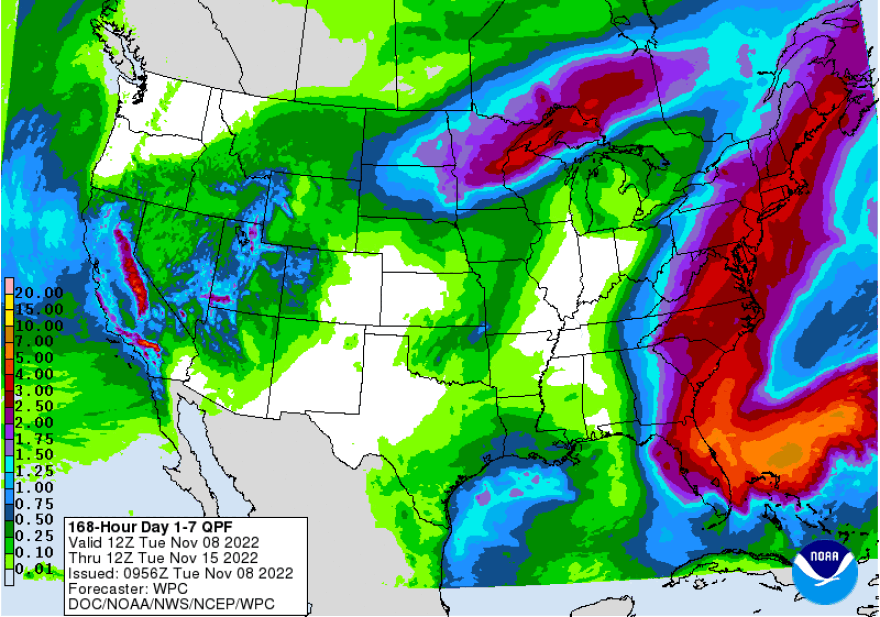
Meteorologists will work in the coming days to nail down areas with a higher risk of flooding, but it's possible the Lehigh Valley could see several inches of rain.
If the storm trends faster, those totals would be a lot lower.
Winds: Given the uncertainty with the track of Nicole and the timing of the interaction between the two systems, forecasters say there also remains quite a bit of uncertainty with wind potential.
At this point, most guidance shows the wind staying well below wind advisory criteria (sustained winds 31 to 39 mph, for better than 1 hour - and/or wind gusts 46 to 57 mph for any duration), but that could change.
Thunderstorms: The weather service says the "primary mode of precipitation" should be rain, but it can't rule out an isolated severe thunderstorm.
