
EMMAUS, Pa. — Envisioning a denser, more walkable and growing borough, officials are looking to implement plans for the future through a full rewrite of land regulations.
Members of the borough government and consultants say they set out to diagnose and update items out of "alignment with community vision" and establish plans, improve processes and regulations, improve consistency between documents, and improve readability in its zoning ordinance and subdivision and land development ordinance (SALDO).
The overhaul creates new zoning districts, a new official map of the borough, and it rewrites both the SALDO and zoning ordinances.
It also serves to reflect recent planning documents and guidelines, such as the Southwestern Lehigh Comprehensive Plan and the borough's Vision 2030 goals, greenways and trails plan, and parks, recreation and open space plan.
Some of those planned priorities include making roads safer and more accessible for pedestrians and cyclists, increasing mixed-use projects, preserving the South Mountain Trail corridor, implementing traffic calming measures, and improving street aesthetics.
At the Emmaus Borough Council meeting Monday, members did a first read of the ordinance to establish a new borough map, while tabling the SALDO and zoning ordinances pending final amendments and adjustments. Councilman Brent Labenberg voiced support for a second public hearing once changes were implemented, but no date was set.
The project kicked off in 2021 and was guided by a task force of borough officials from the zoning hearing board, planning commission, borough council and borough staff, and residents and consulting partners.
Hannah Clark, a representative for the consulting firm Michael Baker International, which worked with the borough on the updates, said the process involved tailoring updates to the borough's needs, as well as documents like the Southwestern Lehigh Multi-Municipal Plan, and the borough's parks, greenways trails and open space plan.

"This is really about operationalizing the borough's vision, where they want to go, and the documents that form this vision," Clark said in a previously recorded informational meeting. "When we began this process with the borough, we were tasked with creating a document that was searchable and maintainable, simple, meaning it was easy to understand access and apply."
Michael Baker International also helped lead the review and revision of land use laws in Upper Macungie Township this year.
Subdivision and land development ordinances regulate lot design and layout, street design and infrastructure improvements. Zoning regulates the uses of private properties such as commercial, residential or industrial.
Public comment was gathered throughout the process, including a public hearing held at the Nov. 6 borough council meeting, where the effort was tabled.
Borough Manager Shane Pepe explained at the hearing then that prior existing uses that would be out of line with the new ordinance would be OK to stay as long as they do not fall out of disuse.
"Anything that exists already is grandfathered," Pepe said. "You can replace a prior nonconforming existing use as long as it fits within the definitions of the prior nonconformity."
The ordinance was tabled at the prior meeting due to inconsistencies in the document related to short-term rentals as an accessory use, allowing RV and boat parking, and allowing pools to be built in the conservation district.
Zoning updates shift uses, districts
A major part of the zoning update is the shifts and changes to zoning districts. It will also govern the makeup, authority, and functions of the borough's zoning hearing board.
Priorities listed for the zoning update are predictability of building form; establishing and maintaining the borough's identity and character; highlighting arts, culture and historic character; having diverse and affordable housing; and promoting infill and redevelopment, including on brownfield sites.
The new ordinance outlines clear restrictions for each new district, including height width coverage and area maximums, along with setback, building form, and frontage requirements. A table of allowed principal uses for future construction is also provided.
The new P-Preservation district, which includes parts of what was formerly designated Conservation-Residential district, is for the preservation of publicly owned land. Principal uses include parks, nature preserves and forestry, along with emergency services.
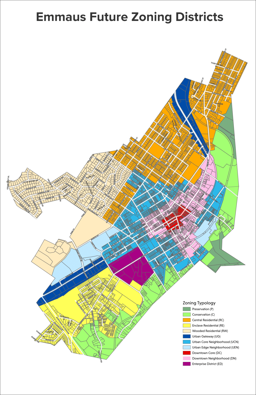
The new C-Conservation is established to conserve natural settings of hillside, tree coverage and natural landscape. It is intended to promote small building footprints that leave most of the lot untouched and include parts of the former R-L Low Density Residential and C-R Conservation Residential districts.
The new RW-Wooded Residential is to "preserve the secluded and wooded character" of parts of the formerly R-L Low Density Residential district and to respond to hillside conditions, resulting in slightly larger lots and required building setbacks.
The new RE-Enclave Residential district covers the southwest corner of Emmaus with limited major road access that restricts what could be greater density. The description notes that house sizes vary but consistent setbacks are to complement the walkable scale and cohesive feel of the neighborhood. It encompasses previous C-R Conservation-Residential, R-M Medium Density Residential, and R-L Low Density Residential districting.
The new RC-Central Residential promotes residential uses with moderate density along walkable streets. The description states that it sets out to provide a cohesive feel with varying house sizes. It consists of previous R-RL Low Density and R-M Medium Density zoning areas.
UEN-Urban Edge Neighborhoods is said to create "an opportunity for expanded growth and density as the borough's needs evolve." It is a mixed-use zoning set near the Emmaus High School campus and new UG-Urban Gateway district, and will allow for expanded growth and density close to both shopping and parks. It consists of previous R-M Medium Density Residential, R-HO High Density Residential Office and R-R Conservation Residential district designations. It has irregular block sizes, and allows greater flexibility in building design. The idea is to permit innovative site design and communal open spaces to incentivize higher density.
UC-Urban Core Neighborhood encompasses parts of previous I-L Light Industrial, R-HO High Density Residential Office, R-M Medium Density Residential, B-C Central Commercial and R-L Low Density Residential. It is a mixed-use area with "a variety of building sizes and typologies that are suited to a mix of uses and reflect the historic and traditional character" of the borough. It establishes narrow lots and rear parking access, seeking to make it a walkable and dense urban area.
UG-Urban Gateway corresponds to the primary transportation access routes to the borough, suited to larger commercial and mixed uses, while remaining the "very auto[mobile] oriented" areas of the town. It consists of former B-H Highway Commercial and B-C Central Commercial districts. It is considered an area for growth and allows buildings up to four stories with little to no setback, prioritizing active ground floor use such as retail shops. Rear parking in this area is to be required, and shared parking strategies are "encouraged to promote a redevelopment that is people-oriented and a natural compliment to Emmaus' downtown." It allows the most forms of service and commercial use.
"Setbacks from the street are smaller, because we're trying to create more walkable human oriented streets, areas," Clark said.
"So even in areas that are more auto-oriented, such as the urban gateway, which was previously more or less the highway-commercial, we are seeing ultimately redevelopment closer to the street, so that people have a little more of that sense of downtown Main Street. and it's more inviting for both people who are walking, as well as people who are driving and hopefully getting them to slow down a bit."
DN-Downtown Neighborhood is a mixed-use district for walkable blocks with proximity to Triangle Park and the DC-Downtown Core district. Buildings are closely spaced or attached with little to no setback, with interaction between public sidewalk and building frontage. It is a flexible district with inclusions for residential, retail and office space, and is meant to feel and look like part of Emmaus' downtown. It consists of prior B-C Central Commercial, R-HO High Density Residential Office, R-M Medium Density Residential and B-H Highway Commercial districting.
DC-Downtown Core is the primary "heart" of the borough directly around Triangle Park and nearby blocks. It is to be "preserved and enhanced" as the historic center with shopping, retail and other active uses alongside residential. Up to five stories are permitted with parking delegated to the rear, prioritizing pedestrian access. This covers prior B-C Central Commercial District zoning.
ED-Enterprise District is on the former I-L Light Industrial District, allowing industrial uses and redevelopment "more flexibly" than in other districts. Height and siting can vary widely to enable uses to this end.
The actual document became condensed, turning the original 11 part ordinance to six.
Amendments made since the last major update, such as the age qualified community and medical marijuana facilities, are implemented into the main ordinance as well.
The current draft of the new ordinance can be viewed here.
New land development regulations and borough map
In tackling the borough's SALDO update, goals were set out such as incorporating sidewalk requirements, standardizing development review processes, updating stormwater management, reviewing street guidelines, and keeping aesthetics consistent.
The update seeks development standards that "provide a suitable balance between historic integrity and contemporary best practices in architecture and construction" along with consistent and walkable development.
Clark says it is a "complete overhaul" of the prior documents, updating items like street and intersection designs, outdoor lighting, and the subdivision process. It also provides specific dimensions for key development items, such as parking spaces, vegetation and preservation of natural features.
It also governs the process for the application and approval of subdivisions and land development projects through the planning commission and borough council.
The current draft of the new ordinance can be viewed here.
The new official map, which passed its first reading Monday, fits in the equation with the other actions by outlining planned changes to the borough.
Clark says the official map is a tool that will identify the location of current and planned public land and facilities, such as street widening, intersection improvements proposed parks and trails, and conserved open spaces.
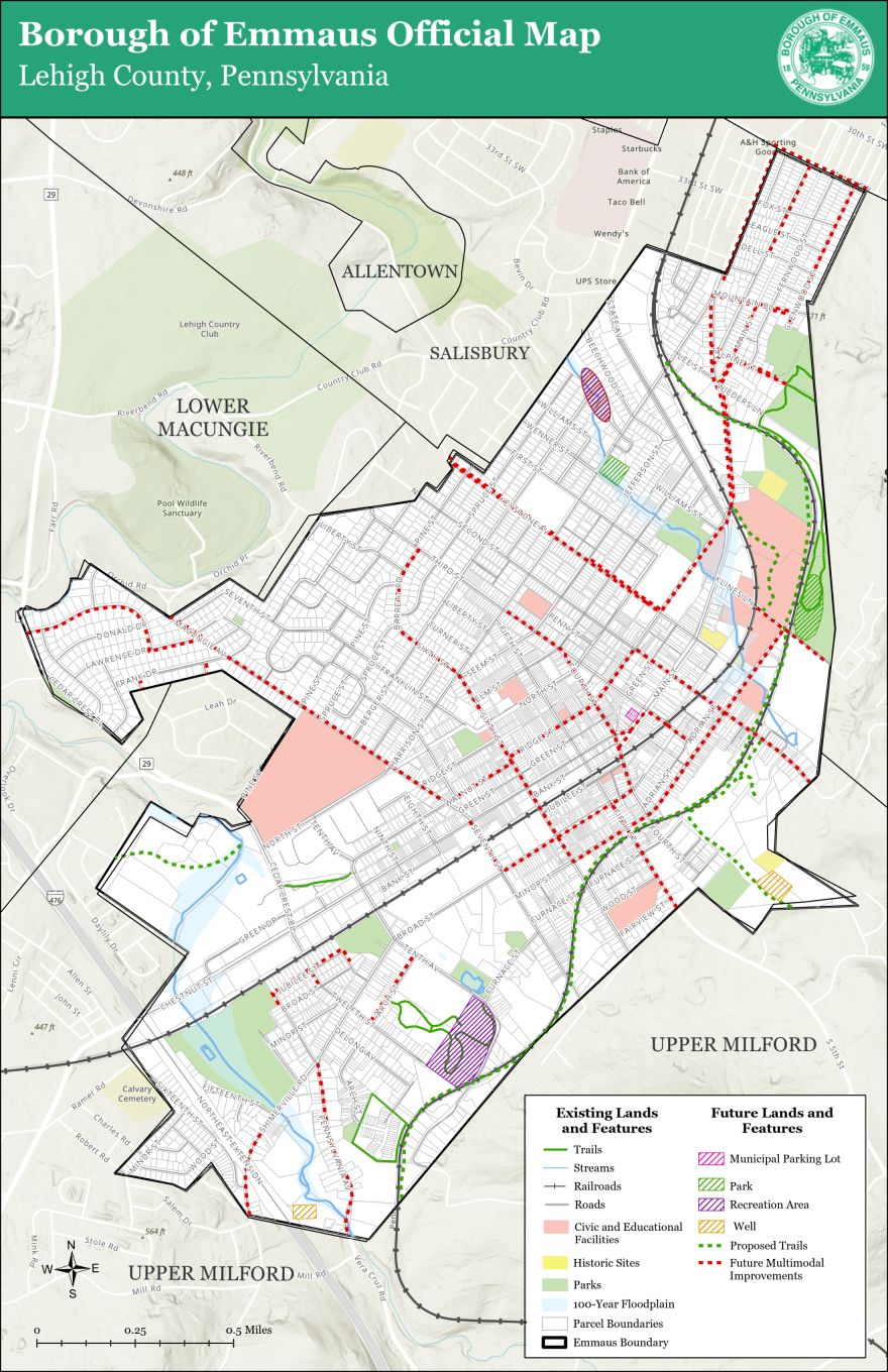
Officials say the new official map allows continuous updates as a "living document" that can be continuously updated via ordinance if plans change in the future. It outlines planned trails and multimodal improvements, while highlighting lands for planned or potential parks, and recreation areas.
The map adds the recently established municipal parking lot at 311 Main St. in Emmaus.
The official map is planned for a final vote during borough council's Dec. 18 meeting.