

BETHLEHEM, Pa. — Drier air will filter into the region this weekend, forecasters say, with near- to below-normal temperatures favored in the days and weeks ahead.
The National Weather Service predicts highs in the upper 80s to near 90 degrees both Saturday and Sunday before dew points and temperatures fall, with highs in the upper 70s to low 80s next week.
An outlook from the Climate Prediction Center shows the chance for below-normal temperatures through at least Aug. 28.
But just as the Lehigh Valley’s forecast is cooling off, the Atlantic hurricane season is heating up.
There will be potential impacts along the East Coast from Hurricane Erin, including a high risk for rip currents and minor coastal flooding, affecting shore points as early as Monday and lasting through much of next week.
Here’s what to know.
Erin is the season's first hurricane
The Atlantic hurricane season officially runs from June 1 through Nov. 30, with activity typically peaking from mid-August through September.
The first named storm, Andrea, formed on June 23, marking the latest start to the season since 2014. Subsequent storms included Barry, Chantal and Dexter.
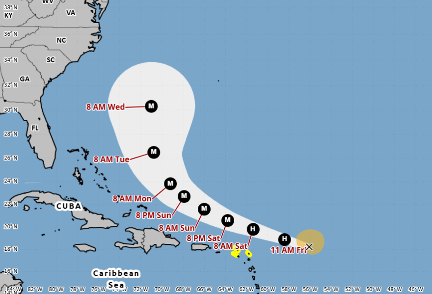
According to the National Hurricane Center, Erin has developed into the first official hurricane of the season and could reach major hurricane (Category 3+) strength over the weekend.
While it poses threats such as dangerous surf, rip currents and rough seas, it remains on track to avoid land and should pose no direct threat to the United States, experts said.
What could turn up the dial
Experts say the Atlantic Ocean has heated up over the past month as peak hurricane season approaches.
And while warmer-than-average water doesn't guarantee storms, it can contribute to more moisture-laden and stronger systems.
But there are other factors that also could play a big role moving forward.
On Thursday, the Climate Prediction Center issued a La Niña watch, with a brief period of La Niña conditions favored in the fall and early winter for 2025-26.
The hurricane impacts of El Niño — and in this case, its counterpart La Niña — are described by the National Oceanic and Atmospheric Administration as a “see-saw between the Pacific and Atlantic oceans.”
La Niña suppresses hurricane activity in the central and eastern Pacific basins, and enhances it in the Atlantic basin.NOAA/NWS
Simply put, El Niño favors stronger hurricane activity in the central and eastern Pacific basins, and suppresses it in the Atlantic basin.
On the flip side, La Niña suppresses hurricane activity in the central and eastern Pacific basins and enhances it in the Atlantic basin.
The impacts are caused by changes in the vertical wind shear, or changes in wind speed and direction 5,000 to 35,000 feet above the ground.
Strong vertical wind shear can tear apart a developing hurricane or prevent it from forming.
Over the Atlantic, weaker upper- and lower-level winds can reduce the wind shear and increase hurricane activity.
La Niña also favors increased Atlantic hurricane activity by decreasing the amount of sinking motion and atmospheric stability.
Is hurricane season still on track?
On Aug. 7, NOAA said atmospheric and oceanic conditions continue to favor an above-normal season as the organization first predicted in May.
Forecasters from the National Weather Service updated the number of expected named storms to 13-18 (with winds of 39 mph or greater), of which five to nine become hurricanes (winds of 74 mph or greater), including two to five major hurricanes (winds of 111 mph or greater).
The adjusted ranges are for the entire season though Nov. 30, and are inclusive of the four named tropical storms that have already formed.
In the Atlantic basin, a typical hurricane season yields 14 named storms, of which seven become hurricanes and three become major hurricanes.
