BETHLEHEM, Pa. — Welcome to the warmest week of the year in the Lehigh Valley, and that’s not just based on the current forecast.
The third week of July is the warmest week of the year based on climatological norms, the National Weather Service tweeted Sunday.
- It's the warmest week of the year in the Lehigh Valley based on climatological norms
- It's also expected to be the warmest week of the year based on the forecast, with the first excessive heat headlines of the year likely across the region
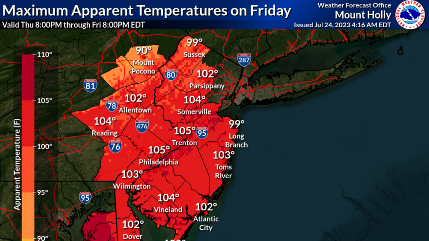
- The hottest day of the week is expected to be Friday, with high temperatures reaching the middle to upper 90s north to south
On July 24, the Lehigh Valley’s sunrise occurs at 5:51 a.m. and sunset arrives at 8:25 p.m., good for 14 hours, 33 minutes and 39 seconds of daylight.
The average historical high in Allentown for the date is 86 degrees and the average low is 65 degrees.
Average temperatures are expected to slowly decrease over the next couple of weeks, with daylight dropping off rapidly.
By the end of August, the area will have 13 hours, 7 seconds of daylight.
Here comes the heat
At this time last year, the region was mired in a week-long stretch of oppressive heat that spanned from July 19-25.
But the heat wave expected in the Lehigh Valley this week should be in and out quickly, forecasters say.
It comes as a trough protecting the region from excessively hot temperatures begins to lift for the end of the week.
“A surface high off the coast will establish a southerly flow of hot, humid air into our region,” meteorologist Dean Iovino said in the latest forecast discussion from the weather service forecast office in Mount Holly, New Jersey.
“A surface high off the coast will establish a southerly flow of hot, humid air into our region"Meteorologist Dean Iovino
The first excessive heat headlines of the year are likely across the region later this week, the forecast discussion said.
The hottest day of the week is expected to be Friday, with high temperatures reaching the middle to upper 90s north to south, with maximum heat index values possibly into the 100 to 108 range.
Will records fall?
Even with tweaks to the forecast likely, a few spots may come close to setting records this week, the weather service said on Twitter.
Allentown’s record high for July 28 is 97 degrees, set in 1949.
1/2 After a nearly perfect weekend, we look ahead to the new week. The heat returns as the week progresses, with Friday shaping up to be the hottest day, possibly of the year. Although tweaks to the forecast are likely, a few spots may come close to setting records. pic.twitter.com/W109hIiqf0
— NWS Mount Holly (@NWS_MountHolly) July 23, 2023
“What we really have to watch is the heat index,” the NWS said. “It will be quite humid with dew points in the lower 70s, resulting in heat index values in excess of 100°, possibly even over 105°.”
But the heat won’t linger. A cold front is expected to arrive from the northwest on Saturday, resulting in an increase in the potential for afternoon and evening showers and storms.
High temperatures by Sunday are expected to favor the low to mid 80s in the Lehigh Valley.


