
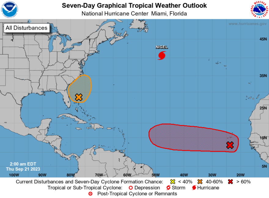
- A coastal storm is expected to bring a rainy, windy weekend to the region
- It's possible the system earns the name "Ophelia," which would be the 15th named storm of the 2023 Atlantic hurricane season
- Total rainfall amounts for the area remain in question
BETHLEHEM, Pa. — It’s becoming increasingly probable that a subtropical storm develops off the Southeast coast this weekend, forecasters say, but expected impacts to the Lehigh Valley remain in question.
There’s even a chance the system earns the name “Ophelia,” which would be the 15th named storm of the 2023 Atlantic hurricane season. Early Thursday, the National Hurricane Center gave it roughly a 40% chance of cyclone formation.
Whether or not it’s named, the storm is expected to bring gusty winds, heavy surf, dangerous rip currents and heavy rainfall to the East Coast this weekend.
But it’s still unknown what areas will be most affected, and it’s entirely possible the Lehigh Valley will avoid the heaviest rainfall.
A coastal storm is increasingly likely to affect the region Friday night-Sunday. Besides the flood potential mentioned in the graphic, wind may gust up to 40 mph inland & 50 mph near the coast, which may cause coastal flooding, beach erosion & rips. Not a very nice weekend. pic.twitter.com/qExT1tSUKc
— NWS Mount Holly (@NWS_MountHolly) September 20, 2023
Here’s what we know:
How is the storm developing?
Early Thursday, the system was nothing more than an area of disorganized showers and thunderstorms to the east of the Florida Peninsula.
But ultimately, it will become a coastal low pressure system strengthening offshore, to the southeast of the Carolinas.
In news reports, you’ll potentially hear the storm referred to as a “mid-latitude” cyclone. According to the National Oceanic and Atmospheric Administration, that's a large-scale low pressure system that forms along weather fronts in Earth's mid-latitudes (usually between 30° and 60° latitude from the equator).
In the continental United States, such storms most often occur from late fall to early spring when the temperature contrast between warm and cold air masses is greatest.
Why has it been difficult to forecast?
The system will not be fully tropical, nor run-of-the-mill, forecasters say.
That’s because it’s feeding off both jet stream energy and the warm waters of the Gulf Stream. But eventually, it will be partially cut off from the main jet stream flow, blocked by high pressure to our north.
“These kind of storm systems can often be slow-moving and notoriously difficult to forecast,” the National Weather Service said Thursday, noting a big key will be the timing and strength of a low-pressure system tracking eastward across Ontario and Quebec on Friday.
Forecasters say guidance is in decent agreement in the coastal storm ultimately tracking north, but an area of low pressure may be “left behind” to drift around the region Saturday night into Sunday, making much of the weekend wet and windy.
What are the expected impacts?
“We’re talking about whether this is going to be a coastal low or subtropical low," EPAWA meteorologist Bobby Martrich said in his latest video forecast. I’m leaning against the subtropical characteristics with this."
EPAWA's 9/21 and week ahead outlook, covering:
— Bobby Martrich | EPAWA (@epawawx) September 21, 2023
■ Dry and pleasant conditions to end the work week
■ Coastal system affects the weekend with rain
■ Preliminary ideas with rain amounts/placementhttps://t.co/MeSxMBXAHj
“I don’t think it has enough time. It’s not impossible that right before it reaches landfall they might designate this [as Ophelia], but it’s a semantics thing. It really is.”
Martrich called the storm a “hybrid system” expected to drop the heaviest precipitation to the east of the Lehigh Valley on Saturday. But that doesn’t mean we’re going to stay dry, even as models disagree on the northward extent of the steadier rain Saturday.
Some models show an “area-wide event” that brings rain across the entirety of Pennsylvania, though forecasters say the “best compromise” of forecast amounts suggest 0.75 to 1.5 inches of rain will fall through Saturday night northwest of Interstate 95, with 1.5 to 2.5 inches to the southeast. The highest amounts will fall along the coast from Cape May to coastal Delaware.
Sunday still could feature periods of steadier rain, but amounts don't look as high as Saturday, forecasters say.
Overall, this is expected to be more of a nuisance than a destructive storm, especially for the Lehigh Valley.
