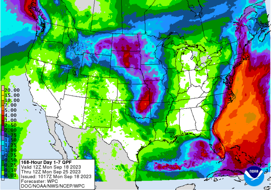
- The National Hurricane Center has highlighted an area for possible development along the southeastern United States this week
- The system could move north or northwestward, bringing widespread precipitation
- We should expect further refinements of the forecast in the coming days
BETHLEHEM, Pa. — What’s the difference between a subtropical and tropical storm?
Lehigh Valley residents might be interested in the answer to that question this week, with the long-range forecast hinting at a system impacting the region by the weekend.
“Despite the fancy subtropical storm possible designation, it’s just rain here" if the storm arrives, EPAWA meteorologist Bobby Martrich said via text Monday. “But it could be a decent amount initially.”
In his Monday video forecast, Martrich noted that the National Hurricane Center highlighted an area for potential development across the Southeastern U.S. coastline.
EPAWA's 9/18 and week ahead outlook, covering:
— Bobby Martrich | EPAWA (@epawawx) September 18, 2023
■ Timing the exit of the cold front/showers today
■ Several consecutive dry days follow this week
■ Watching a coastal/subtropical low this weekendhttps://t.co/ucMPyL6p7I
By 11 a.m. Monday, it had a 30% chance of cyclone formation over a seven-day period. According to the NHC, the system “could acquire some subtropical characteristics this weekend if it remains offshore while it moves slowly northward or northwestward.”
Tropical vs. Subtropical
The biggest differences between tropical and subtropical storms are in the way they form and in the broad impacts.
Tropical storms are areas of low pressure fueled by the warm waters in the Gulf and along the Southern coast. The warm water helps to supply the energy to the storm, with the heaviest rain closest to the center. Those storms also typically have a smaller wind field.
Subtropical storms also are areas of low pressure, but warm waters and temperature changes are what help to supply the energy. Those storms usually see heavier rain farther from the center, and the wind field usually expands a greater distance from the center of circulation.
The most important thing to remember, according to the National Weather Service, is that tropical systems have the potential to quickly grow into hurricanes, while subtropical storms do not.
However, if a subtropical storm remains over warm water long enough, it eventually may become fully tropical.
How much rain could we get?

Forecasters say it’s a little too early to answer that question, but precipitation could spread through Saturday, Saturday night and Sunday if things come together.
The latest forecast discussion from the NWS forecast office in Mount Holly, New Jersey, said several model solutions bring widespread rain into the area by late Saturday, continuing into Sunday.
“Expect further refinements of the forecast as this is still at the day 6-7 range, but just worth noting that the overall trend seems to be wetter for our area,” the discussion said.
“Also, there are some indications that the system could tap into tropical moisture meaning rain amounts could end up being significant.”
Martrich said there is one thing to watch that will dictate the potential for subtropical designation — how much time the system spends over the warm waters of the gulfstream late in the week.


