
BETHLEHEM, Pa. — A complex storm system will bring snow to the Lehigh Valley on Friday before temperatures tumble, forecasters warn.
The National Weather Service said much of the guidance suggests that the steadier snow will focus more on southern New Jersey into Delaware during the peak of the event, lingering there the longest.
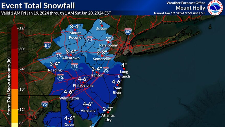
The Lehigh Valley remains under a winter weather advisory until 10 p.m. for total snow accumulations of 2 to 4 inches.
The lowest amounts will be found north of Interstate 80, the advisory suggests, while the highest amounts will be south of Interstate 78.
Many area schools are closed or have moved to remote instruction.
The state Transportation Department and the Pennsylvania Turnpike Commission also imposed restrictions on highways because of winter conditions, dropping speed limits to 45 mph.

The science of the storm
These are the elements forecasters are closely watching as the storm develops:
Location: The Lehigh Valley appears out of the running for the heaviest snow. Instead, since Thursday afternoon, model guidance has made a distinct shift south of our area with the axis of heavier snow amounts, the weather service said in its latest forecast discussion.
Dry air: While snow was beginning to break out in the predawn hours, it’s not expected to pick up in intensity until mid- to late morning. That’s because it’s fighting lower-level dry air and there’s a process going on known as the wet bulb effect.
EPAWA's 1/19 and week ahead outlook, covering:
— Bobby Martrich | EPAWA (@epawawx) January 19, 2024
■ Breakdown of today's wintry system with timing
■ Cold weekend with blustery conditions expected
■ A warming trend follows heading into next weekhttps://t.co/iSoSt1rQhu
To see snow fall and begin to accumulate, we’ll have to see the drier air near the surface cooled and moistened as evaporation happens. Eventually the temperature will cool to a low enough point to support snow.
Timing: While the snow may have a chance to linger into the evening closer to the coast, it’s expected to quickly diminish elsewhere as progressively drier air filters into the region.
EPAWA meteorologist Bobby Martrich said in his latest video forecast that models depict a pretty abrupt ending in the Lehigh Valley, with snow moving out in the early evening hours.
The blustery cold
Forecasters say there’s a very cold weekend on tap, with gusty west to northwest winds lasting into Sunday.

High temperatures are expected to be in the teens and low 20s on Saturday, with wind chill values in the single digits for the Lehigh Valley and below zero in the Poconos.
Wind chills Sunday will mostly be in the teens, the weather service said.
