BETHLEHEM, Pa. — A thunderstorm with 60 mph winds and quarter-sized hail rolled through the region around 9 a.m. Monday, setting the table for what could be a day of severe weather.
The Lehigh Valley is now under a flood watch and severe thunderstorm watch, with additional storms expected to bring damaging winds, hail, flooding or even a tornado or two across the region.
It comes after hit-or-miss storms over the weekend dropped inches of rain in some areas, but almost no rain in other locations.
- The Lehigh Valley is under a flood watch Monday in effect from 2 p.m. through this evening
- Severe storms are likely and could bring hail, damaging winds and a few tornadoes
- Wet weather is in the forecast for the region through at least midweek
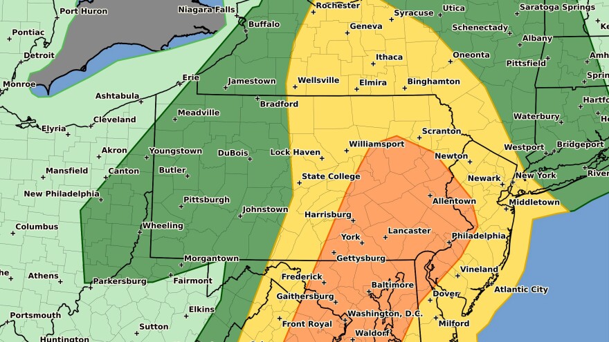
The Storm Prediction Center in Norman, Oklahoma, upgraded the Lehigh Valley around 1 p.m. from a slight risk to an enhanced risk of severe weather (3 out of 5) on Monday, with the Philadelphia metro area and points south also at an enhanced risk.
The severe thunderstorm watch followed.
12:12pm CDT #SPC_Watch WW 391 SEVERE TSTM DE NJ NY PA LE LO CW 261710Z - 270100Z, https://t.co/7wYVzwzFsk pic.twitter.com/Bfzj47hNsI
— NWS Storm Prediction Center (@NWSSPC) June 26, 2023
Timing
Forecasters say multiple rounds of thunderstorms will be possible in parts of the Mid-Atlantic and Northeast, “with a favorable unstable environment” in advance of a cold front.
A mix of storm clusters and a few marginal supercells are expected through the afternoon into the early evening.
WATCH: Live weather camera at SteelStacks outside of our newsroom
Supercells are the least common type of thunderstorm, but have a high likelihood of producing severe weather. What makes a supercell unique from other thunderstorm types is that it contains a rotating updraft that may result in hail or tornadoes.
In the Lehigh Valley, the timeframe to expect additional severe storms will be from 3 p.m. to 9 p.m. as the storms move west to east.
Hazards
“I don’t think we’re going to be mentioning droughts much longer,” EPAWA meteorologist Bobby Martrich said in his Monday video forecast.
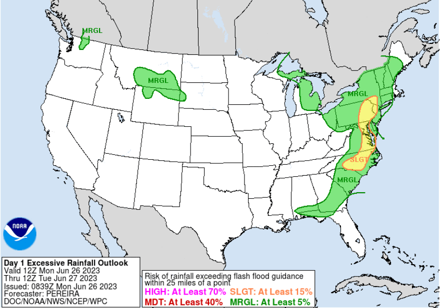
That’s because the flood watch indicates widespread rainfall amounts of 1-2 inches, with localized amounts of 3-5 inches expected.
EPAWA's 6/26 and week ahead outlook, covering:
— Bobby Martrich | EPAWA (@epawawx) June 26, 2023
■ Severe weather Monday timing, expectations
■ More scattered storms expected thru midweek
■ Early look at the upcoming holiday weekendhttps://t.co/J6gQQ7MRyr
Those totals are expected to result in flash flooding in some areas, especially with excessive runoff of creeks, streams and other low-lying and flood-prone locations. Motorists are advised that low-water crossings may be flooded.
Beyond precipitation, damaging winds of 60-70 mph are expected to be the most likely hazard from any storms on Monday, with those discrete cells posing a threat of hail and perhaps a tornado or two, forecasters warn.
“In large part, I agree with" the outlook from the Storm Prediction Center, Martrich said. “I will tell you don’t focus on the categories so much … it’s going to do what it’s going to do.”
Martrich focused on the tornado threat for the region, mentioning he believed the threat was “more than a brief spin-up” based on the models he’s studied.
A wet pattern ahead

The rain threats in the Lehigh Valley and surrounding areas will continue through at least midweek.
The area is at risk of excessive rainfall Monday, with the Weather Prediction Center stating, “While the transient nature of the system and developing cold pools are likely to support progressive storms, the environment is expected to generate intense rainfall rates.”
A few thunderstorms Tuesday afternoon and evening could be strong to severe, and some additional showers and thunderstorms are expected on Wednesday.


