BETHLEHEM, Pa. — While Monday night’s storm failed to live up to its full potential, the Lehigh Valley will deal with one more day of wet and stormy weather.
Flood advisories expired at 5:45 a.m. Tuesday for Berks, Lehigh and Northampton counties.
- The Lehigh Valley escaped the worst of Monday night's storms
- Flood advisories expired at 5:45 a.m. Tuesday
- There's one more day of stormy weather on tap, with a marginal risk for severe weather
At 3:33 a.m., the National Weather Service said Doppler radar and automated rain gauges indicated heavy rain from thunderstorms.
Minor flooding was expected in low-lying and poor drainage areas, with some locations getting more than 1.5 inches of rain before the system pulled away.
Tuesday’s forecast
The weather service said an additional round of isolated to scattered showers and storms is forecast Tuesday afternoon and early evening. Some storms could be severe, with damaging winds possible.
The Storm Prediction Center has the Lehigh Valley at a marginal (1 out of 5) risk of severe weather.
⛈️ An additional round of isolated to scattered showers and storms is forecast for this afternoon and early evening. Some storms could be severe, with damaging winds possible. Otherwise, it'll be a warm and humid day with partly to mostly cloudy skies. #PAwx #NJwx #DEwx #MDwx pic.twitter.com/7yGQzNsE2f
— NWS Mount Holly (@NWS_MountHolly) August 15, 2023
According to the SPC, the greatest risk appears to evolve during the late afternoon hours, from southern New Jersey all the way to the Carolinas.
Storms should begin to diminish into the evening, with any remaining storms moving offshore overnight.
A busy year for the NWS
The National Weather Service Mount Holly county warning area encompasses eastern and southeastern Pennsylvania (including the Philadelphia metropolitan area), and all but far northeast New Jersey, Delaware and northeastern Maryland.
The office covers the second-largest population by an NWS forecast office in the country. Office responsibilities include watch/warning operations, especially for severe weather.

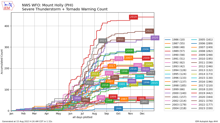
The office has issued a total of 296 severe thunderstorm warnings and 34 tornado warnings so far in 2023, according to data from the Iowa Environmental Mesonet.
The data is an accumulated total of office-issued watches, warnings and advisories. The totals are not considered official and are based on IEM processing of NWS text warning data. The totals are for individual warnings.
Compared with data going to 1986, this is one of the more active years for severe storm warnings in the area.
The office’s CWA had 442 severe storm or tornado warnings in 2019, tops for the data period.
According to a preliminary severe weather report database compiled by the National Oceanic and Atmospheric Administration, there have been 20 confirmed tornadoes in Pennsylvania this year.


