
- A tropical system now dubbed Ophelia will drench the East Coast this weekend, including the Lehigh Valley
- The threat and confidence of widespread impacts from the storm have increased, which includes coastal flooding, damaging winds and heavy rainfall
- Expected rainfall totals have increased for the area, with a widespread 2-3 inches now a possibility
BETHLEHEM, Pa. — A tropical system now dubbed Ophelia will drench the East Coast this weekend, including the Lehigh Valley, officials said.
The National Weather Service said the threat and confidence of widespread impacts from the storm have increased. Coastal flooding, strong to damaging winds, and locally heavy rainfall all are expected.
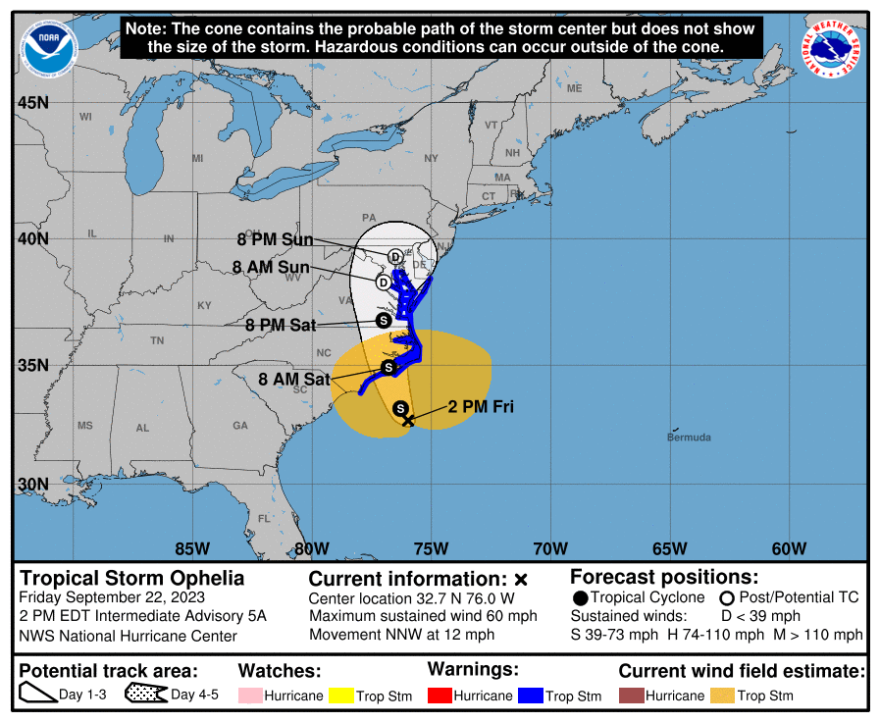
The National Hurricane Center officially named the storm Friday afternoon, but the forecast looks much like it has for the past several hours, with a soaking headed our way.
Tropical Storm #Ophelia Advisory 5A: Cyclone Becomes Tropical Storm Ophelia. Tropical Storm Conditions Continuing Across Coastal Portions of North Carolina. https://t.co/tW4KeGe9uJ
— National Hurricane Center (@NHC_Atlantic) September 22, 2023
The latest
As of 2 p.m. Friday, the National Hurricane Center indicates that "Tropical storm conditions are expected along portions of the southeastern and mid-Atlantic U.S. coasts within the Tropical Storm Warning area today into Saturday night."
The system will also produce heavy rainfall that can cause flash floods across the Mid-Atlantic states from North Carolina to New Jersey until Sunday, according to the forecast.
Widespread impacts
The NHC said there is a danger of life-threatening storm surge inundation over parts of eastern North Carolina and southeastern Virginia.
Storm Surge Warnings are in place and residents are advised to follow advice given by local officials.
Swells generated by the system likely will cause life-threatening surf and rip currents, the NHC said.
Heavy rainfall from the storm is expected to cause urban and small-stream flooding impacts from North Carolina to New Jersey through Sunday.
Local impacts
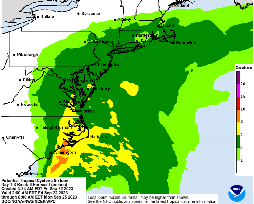
Meteorologist Matthew Cappucci of the Washington Post and MyRadar Weather said plentiful rainfall is expected with this “waterlogged” storm system, and the NWS forecast office in Mount Holly has increased expected rainfall totals.
The Lehigh Valley could see a widespread 2 to 3 inches of rain this weekend, though it’s still possible our area ends up “less moist and more stable,” the latest forecast discussion said.
The rain would begin early Saturday, with precipitation in the forecast through Sunday and perhaps into Monday.
EPAWA meteorologist Bobby Martrich said he expected the system to become a “formidable” tropical storm for parts of North Carolina and a post-tropical depression when it reaches the Chesapeake Bay.
EPAWA's 9/22 and week ahead outlook, covering:
— Bobby Martrich | EPAWA (@epawawx) September 22, 2023
■ Clouds increase Friday ahead of weekend storm
■ Tropical storm turned nor'easter this weekend
■ All impacts and timing and what to expect locallyhttps://t.co/K5q2bZwsrC
“When it’s a post-tropical depression it’s technically a nor’easter at that time when it’s affecting us," he said of the system. "You can’t make this stuff up.
“But the bottom line is the impacts will not change no matter what they name it or what you want to call it.”
