

BETHLEHEM, Pa. — The temperature dropped to 48 degrees at Lehigh Valley International Airport early Thursday, giving the area its coldest August morning in 17 years.
And, if you’re loving this early taste of fall, forecasters have a message:
There’s more where that came from.
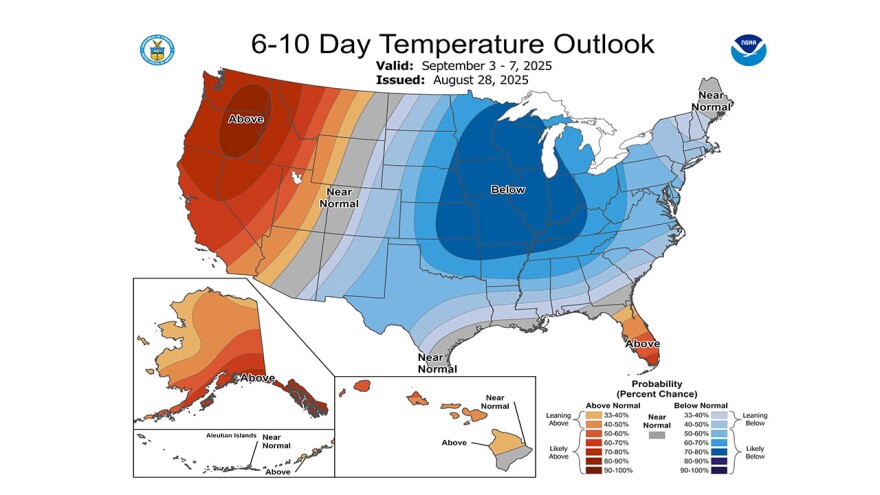
The National Weather Service said temperatures are forecast to remain below average in the days ahead, with a sweeping cold front expected to bring more fall-like weather to the Great Lakes, Ohio Valley, the Northeast, and Mid-Atlantic over the next few days.
High temperatures will mostly top out in the 60s and 70s, with overnight lows dipping into the 40s and 50s, the weather service said.
And, meteorologist Bobby Martrich of EPAWA Weather Consulting went a step further, declaring an official end to summer.
It’s time, Martrich said, to put a lid on the season. He sees no sign of extreme heat returning.
“The 90s are done,” he said Friday. “Probably the mid-upper 80s, too.”
"The 90s are done. Probably the mid-upper 80s, too."EPAWA meteorologist Bobby Martrich
What's driving the pattern?
The latest EPAWA long-range outlook highlights how “cooler than average conditions have been present over the past week to 10 days across the region, and are likely to continue for the remainder of August and first week to 10 days of September.”
Martrich said the pattern is from a negative EPO, allowing an upper air flow that originates from Canada, with persistent cooler toughs invading the eastern United States.
A negative EPO, or Eastern Pacific Oscillation, is a weather pattern that affects how air moves over the Pacific Ocean and North America.
When the EPO is negative, high pressure tends to build over Alaska and the northern Pacific, blocking warmer air from flowing into the U.S.
Instead, it allows colder air from the Arctic to slide south and infiltrate the U.S.
Martrich said a negative EPO often means colder weather.
“In wintertime, this type of pattern leads to severe cold outbreaks, but in late summer the result isn’t cold, but rather notably cooler temperatures relative to average,” his outlook said.
The end result has been temperatures "more reminiscent of September rather than late August.”
What could it mean for winter?
Martrich typically doesn’t look ahead beyond a six-week window, explaining “it’s either feast or famine in this kind of background state (referring to the pre-existing, large-scale conditions of the atmosphere that influence the development of more localized weather).
The winter, he said, can very easily be very warm, just as much as it can be very cold.
“It’s all going to come down to the EPO this year I think. Negative is cold. Positive is warm. Fairly simple concept. But the North Pacific sea surface temperatures would support the former. We’ll see where we are in a few months.”
The weather service said Friday that much of the area has experienced its coldest August in about 10 years, since either 2017 or 2014 depending on the exact station across the Mid-Atlantic.
Martrich said temperatures should return to near or slightly above average from the middle of the second week of September onward, through at least early October.
Then, we wait and see.
