

BETHLEHEM, Pa. — A winter weather advisory remains in effect until 4 p.m. Wednesday for counties along and north of I-78, including Lehigh, Northampton and Berks.
After changes in the overnight trends altered expected impacts from a winter storm, snow arrived right on time and was falling across much of the region by 11:30 a.m.
Roads, sidewalks and lawns were quickly coated in Allentown and other areas.
Meteorologists pushed back the storm's arrival time and noted early, "There’s not one model agreeing with the next."
But hours out from the arrival of the snow, they pegged the 11 a.m. to noon time frame.
Just like that, down it came.
- A winter weather advisory remains in effect until 4 p.m.
- Snow overspread much of the area by 11:30 a.m. this morning
- The Lehigh Valley is expecting a quick "burst" of snow that could cause travel impacts before changing to rain
A full on white out happening in Allentown. This looks like the burst, for sure. #snow @NWS_MountHolly @epawawx pic.twitter.com/3GVKMW2kv5
— Stephanie Sigafoos (@ssigafoos) January 25, 2023
While the late arrival bumped expected snowfall totals down slightly, it was sticking from the onset as surface temperatures dropped below 32 degrees.
The storm is expected to reach peak intensity for the Lehigh Valley sometime during the mid afternoon before the snow changes to all rain.
The Lehigh Valley was highlighted as one area where the weather service anticipated travel impacts from the accumulating snow, especially if it exceeded one inch per hour.
It’s also why the Pennsylvania Department of Transportation (PennDOT) and the Pennsylvania Turnpike Commission (PTC) are advising motorists to avoid unnecessary travel during the storm.
Additionally, both agencies will implement various speed and vehicle restrictions throughout the day.
The City of Allentown also said on Facebook it had 39 plow trucks out across the city working on snow removal operations.
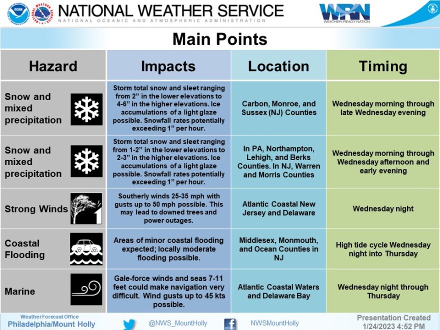
In terms of snowfall totals, the weather service expects 3 to 6 inches in the southern Poconos and up to one tenth of an inch of ice.
The Lehigh Valley is forecast to receive 1 to 3 inches, with the greater amounts and potential for ice in the highest elevations of Northampton County.
Farther west into Lehigh and Berks, snow totals are forecast to remain in the 1 to 2 inch range.
In addition to the wintry precipitation and the heavy rain coming behind the storm, winds are expected to increase to around 15 to 25 mph, with gusts of 30 mph possible in the Lehigh Valley area.
