
BETHLEHEM, Pa. - Is there rain and wind—or something more interesting—in store for the Lehigh Valley in the coming days?
That’s what readers are wondering as a parade of storms begins to roll through the region. But forecasters from the National Weather Service in Mt. Holly, NJ, have offered this warning: There is vast uncertainty with the timing of systems in and around our area into next week.
While timing and final solutions are still up in the air on moisture arriving (or not) for the weekend and beyond, one solution seems a little more final. There’s higher confidence that temperatures will remain close to average, so most areas would see rain, not snow, if there’s any precipitation at all.
“A few snowflakes cannot be ruled out,” the NWS said in its latest forecast discussion, but a lot of unknowns remain, with these specific variables impacting the forecast in the coming days:
The Greenland Block
We told you last week that forecasters were targeting mid-December as a period that looked more conducive for wintry threats thanks to a Greenland Block developing, which forces the jet stream to dip and sends cold air filtering south into the Lower 48, and potentially into the mid-Atlantic region.
But ensemble modeling (strictly speaking, the suite of global weather models meteorologists use to forecast the weather) and long range projections are just that, and forecasters are quick to warn that a better-than-average pattern still doesn’t mean a snowstorm is on the horizon.
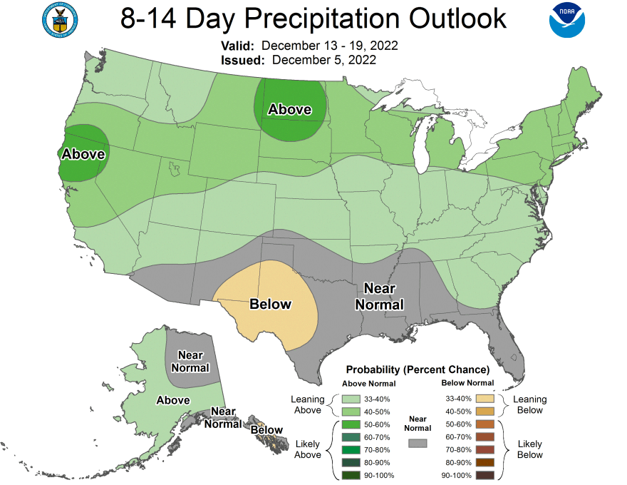
It’s possible this Greenland Block could come and go without much of an impact here at all, and right now the cold air looks delayed, with the government’s Climate Prediction Center showing above-average precipitation chances but warmer-than-average temperatures the next eight-to-14 days.
Storm Tracks
The biggest thing meteorologists will look at in the coming days is the expected track of any storm system heading this way, and formulating forecasts—in part—based on several successive runs of the computer models they’re using. But in the case of the upcoming weekend system, models show the track of the storm diverging significantly as it approaches our region, with the possibility Saturday could remain mostly dry.
No storm means no precipitation.
Moisture and Temperature
Have you ever heard meteorologists use the phrase “moisture-starved” to describe storm systems in the winter?
It’s because the atmosphere often is cold and dry, and approaching systems don’t have the moisture to work with in order to produce significant precipitation of any type. (Dry air can cause any precipitation falling to evaporate before it reaches the ground, making predictions even more difficult).
Temperature also plays a vital role in determining the type of precipitation that reaches the ground, and a change of just a few degrees can mean the difference between cold rain, freezing rain or snow.
Note: The GIF embedded in this story is from TropicalTidbits.com. The product is generated with imagery from a global weather model known as the GFS.
