ALLENTOWN, Pa. - As an early-season storm produces heavy snow and gusting winds in the Great Lakes region, the Lehigh Valley will see changing temperatures as the system moves east.
The National Weather Service says "much below normal temperatures will spread to the East Coast" over the next few days.
- A freeze warning is in effect for the Lehigh Valley and surrounding areas
- Upcoming temperatures are forecast to run about 10 to 12 degrees below normal the rest of the week
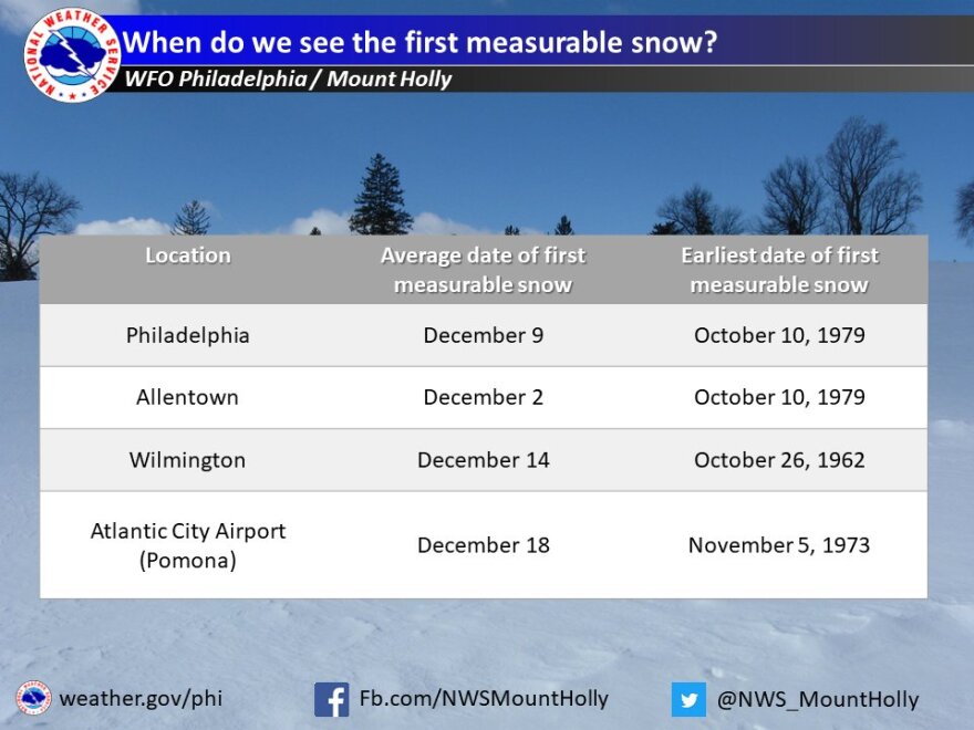
- While the Lehigh Valley has recorded snow as early as Oct. 10, it's not typical. Our first average snowfall is Dec. 2.
A freeze warning is in effect from midnight tonight to 9 a.m. Wednesday, with temperatures in the lower 30s expected.
The warning covers the Pennsylvania counties of Berks, Lehigh and Northampton, along with portions of Chester, Montgomery and Bucks.
Additional freezing temperatures and frost are possible on Wednesday night and Thursday night, the weather service said.
Good Tuesday morning! A colder air mass will continue to settle in today and tonight. Much of the area tonight is expected to experience freezing or frost conditions. This will repeat both Wednesday and Thursday nights. Protect cold sensitive plants. #pawx #njwx #dewx #mdwx pic.twitter.com/6XtSOcp8uu
— NWS Mount Holly (@NWS_MountHolly) October 18, 2022
Frost and freezing conditions will kill crops and other sensitive vegetation, marking the end of the growing season.
With the wintry weather to our west, is it a sign of things to come?
How early has it snowed in the Allentown area?
While areas in the far northern United States and the Rockies will typically see accumulating snow as early as September, that's not the case for our area.
The Lehigh Valley has seen snow as early as Oct. 10 and as late as Jan. 13, but Dec. 2 is the average date for our first snowfall — defined by the weather service as at least a tenth of an inch of accumulation.

What does it mean for us?
While upcoming temperatures are forecast to run about 10 to 12 degrees below normal over the next few days, we're not making an early jump into the winter season. After several chilly days, forecasters say temperatures will be turning noticeably milder for much of the region as we head into the weekend.
"Saturday however, looks to be a nice day with some areas getting into the low 70s for daytime high temperatures," the latest forecast discussion said, while the forecast for Sunday is of "lower confidence."
How another La Niña could impact the upcoming winter
Experts say La Niña is expected to remain in place through this winter, marking our third consecutive year of the pattern.
La Niña is a periodic cooling of the equatorial eastern and central Pacific Ocean and can affect weather patterns around the world, but this so-called "triple-dip" La Niña has only happened twice since 1950.
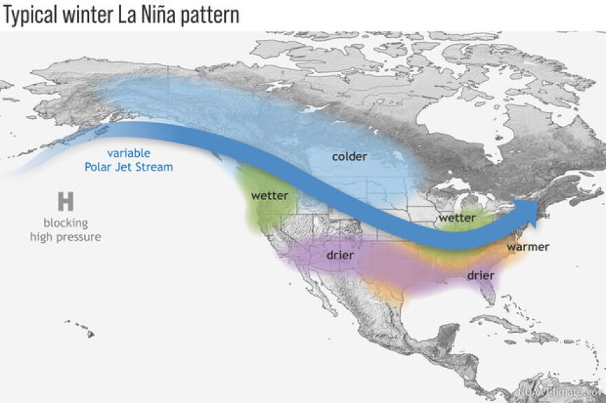
During La Niña, the Lehigh Valley area and the Mid-Atlantic region typically see a wet, warm winter. The actual conditions can vary, however, and will depend on the strength of the pattern.

NOAA's Climate Prediction Center says weaker La Niña seasons can be snowier in the Northeast, while strong La Niña seasons can result in much less snow falling.
Forecast models say the upcoming La Niña looks to be either weak or moderate through the winter, making it difficult to predict how much snow could fall in our area.
The pattern was certainly not a snow amplifier for the Lehigh Valley last winter. Just 19.5 inches fell all winter in Allentown, with only a trace in December and 8.9 inches in January.
February, which is typically our snowiest month, saw just 5.9 inches of snowfall last winter.


